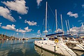
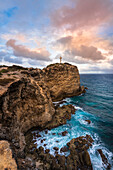
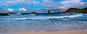
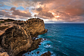
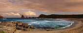
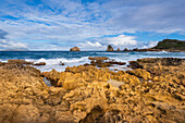
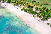
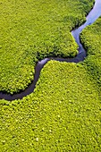
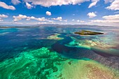
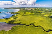
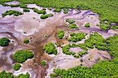
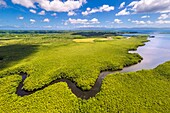
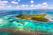
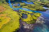
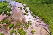
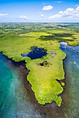
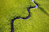
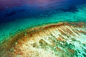
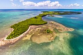
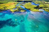
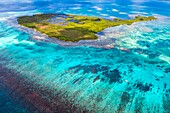
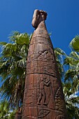
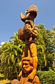
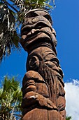
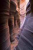
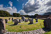
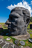
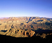
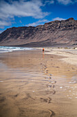
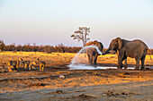
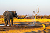
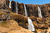
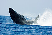
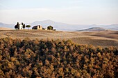
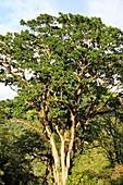
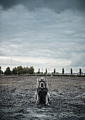
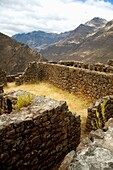
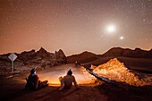
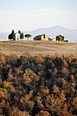
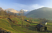
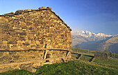
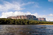
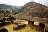
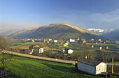
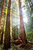
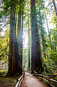
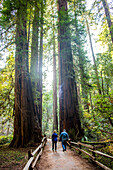
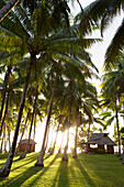
70417046 - Yacht harbor, Port Moselle, Noumea, Grand Terre, New Caledonia13881756 - Grand-Croix at the top of the rocky peninsula of Pointe des Chateaux with a dramatic cloudy sky, Grande-Terre; Guadeloupe, French West Indies13881742 - Waves and seasurf meeting the sandy beach at Grande-Terre with the Grand-Croix in the distance at the tip of Pointe des Chateaux; Guadeloupe, French West Indies13881745 - Grand-Croix at the top of the rocky peninsula of Pointe des Chateaux with a dramatic cloudy sky, Grande-Terre; Guadeloupe, French West Indies13881738 - Sandy beach and peninsula at Grande-Terre with the Grand-Croix in the distance at the tip of Pointe des Chateaux; Guadeloupe, French West Indies13881781 - Waves crashing along the rock formations along the shore at Grande-Terre with the Grand-Croix in the distance at the top of Pointe des Chateaux; Guadeloupe, French West Indies13937805 - France, Caribbean, Lesser Antilles, Guadeloupe, Grand Cul-de-Sac Marin, heart of the Guadeloupe National Park, Grande-Terre, Port-Louis, aerial view of the Souffleur beach\n13933197 - France, Caribbean, Lesser Antilles, Guadeloupe, Grand Cul-de-Sac Marin, heart of the Guadeloupe National Park, Grande-Terre, Port-Louis, aerial view of the Gris-Gris Cove\n13929872 - France, Caribbean, Lesser Antilles, Guadeloupe, Grand Cul-de-Sac Marin, heart of the Guadeloupe National Park, Grande-Terre, Morne-à-l'Eau, Canal Cove, aerial view on the widest mangrove belt of the Lesser Antilles, Biosphere Reserve of Guadeloupe, here the Canal des Rotours, dug over nearly 6 km at the beginning of the 19th century (1826-1830) by hand of Men, slaves, to allow the drainage of the plain\n13937747 - France, Caribbean, Lesser Antilles, Guadeloupe, Grand Cul-de-Sac Marin, heart of the Guadeloupe National Park, Grande-Terre, Port-Louis, aerial view of the Gris-Gris Cove\n13934437 - France, Caribbean, Lesser Antilles, Guadeloupe, Grand Cul-de-Sac Marine, heart of the Guadeloupe National Park, Basse-Terre, aerial view of the Fajou Island pass and the longest coral reef (25 km) of the Lesser Antilles, Biosphere Reserve of the Archipelago of Guadeloupe, La Soufrière volcano chain cleared in the background\n13933770 - France, Caribbean, Lesser Antilles, Guadeloupe, Grand Cul-de-Sac Marin, heart of the Guadeloupe National Park, Grande-Terre, Morne-à-l'Eau, Canal Cove, aerial view on the widest mangrove belt of the Lesser Antilles, Biosphere Reserve of Guadeloupe, here the Canal des Rotours, dug over nearly 6 km at the beginning of the 19th century (1826-1830) by hand of Men, slaves, to allow the drainage of the plain\n13934472 - France, Caribbean, Lesser Antilles, Guadeloupe, Grand Cul-de-Sac Marin, heart of the Guadeloupe National Park, Grande-Terre, Vieux-Bourg, aerial view of the largest mangrove belt in the Lesser Antilles, Biosphere Reserve of Guadeloupe\n13931919 - France, Caribbean, Lesser Antilles, Guadeloupe, Grand Cul-de-Sac marin, heart of Guadeloupe national park, Grande-Terre, Morne-à-l'Eau, Canal cove, aerial view on the wider mangrove belt of the Lesser Antilles, Guadeloupe Biosphere Reserve, here the Canal des Rotours, dug for nearly 6 km at the beginning of the 19th century (1826-1830) by hand of men, slaves, to allow drainage of the plain\n13931196 - France, Caribbean, Lesser Antilles, Guadeloupe, Grand Cul-de-Sac Marine, heart of the Guadeloupe National Park, Basse-Terre, aerial view of the Fajou Island pass and the longest coral reef (25 km) of the Lesser Antilles, Biosphere Reserve of the Archipelago of Guadeloupe, La Soufrière volcano chain cleared in the background\n13930414 - France, Caribbean, Lesser Antilles, Guadeloupe, Grand Cul-de-Sac Marin, heart of the Guadeloupe National Park, Grande-Terre, Basse-Terre, Baie-Mahault, aerial view of the largest mangrove belt in the Lesser Antilles, Guadeloupe Biosphere Reserve, here the Strait of the Salty River\n13937026 - France, Caribbean, Lesser Antilles, Guadeloupe, Grand Cul-de-Sac Marin, heart of the Guadeloupe National Park, Grande-Terre, Vieux-Bourg, aerial view of the largest mangrove belt in the Lesser Antilles, Biosphere Reserve of Guadeloupe\n13935986 - France, Caribbean, Lesser Antilles, Guadeloupe, Grand Cul-de-Sac Marin, heart of the Guadeloupe National Park, Grande-Terre, Morne-à-l'Eau, Canal Cove, aerial view on the widest mangrove belt of the Lesser Antilles, Guadeloupe Biosphere Reserve\n13934368 - France, Caribbean, Lesser Antilles, Guadeloupe, Grand Cul-de-Sac Marin, heart of the Guadeloupe National Park, Grande-Terre, Morne-à-l'Eau, Canal Cove, aerial view on the widest mangrove belt of the Lesser Antilles, Biosphere Reserve of Guadeloupe, here the Canal des Rotours, dug over nearly 6 km at the beginning of the 19th century (1826-1830) by hand of Men, slaves, to allow the drainage of the plain\n13930929 - France, Caribbean, Lesser Antilles, Guadeloupe, Grand Cul-de-Sac Marin, heart of the Guadeloupe National Park, Basse-Terre, aerial view of the coral reef of the Fajou Islet, the longest coral reef (25 km) of the Lesser Antilles, Biosphere Reserve of the Archipelago of Guadeloupe\n13933711 - France, Caribbean, Lesser Antilles, Guadeloupe, Grand Cul-de-Sac Marin, heart of the Guadeloupe National Park, Basse-Terre, aerial view of the Fajou Islet and the longest coral reef (25 km) of the Lesser Antilles, Biosphere Reserve of the Archipelago of Guadeloupe\n13930095 - France, Caribbean, Lesser Antilles, Guadeloupe, Grand Cul-de-Sac Marin, heart of the Guadeloupe National Park, Grande-Terre, Basse-Terre, Baie-Mahault, aerial view of the largest mangrove belt in the Lesser Antilles, Guadeloupe Biosphere Reserve, here the Strait of the Salty River\n13929824 - France, Caribbean, Lesser Antilles, Guadeloupe, Grand Cul-de-Sac Marin, heart of the Guadeloupe National Park, Basse-Terre, aerial view of the Fajou Islet and the longest coral reef (25 km) of the Lesser Antilles, Biosphere Reserve of the Archipelago of Guadeloupe\n71051611 - Wooden statues in the sculpture garden of La Foa, West coast of Grand Terre, New Caledonia, Melanesia, South Pacific, Pacific71051610 - Wooden statues in the sculpture garden of La Foa, West coast of Grand Terre, New Caledonia, Melanesia, South Pacific, Pacific71051612 - Wooden statues in the sculpture garden of La Foa, West coast of Grand Terre, New Caledonia, Melanesia, South Pacific, Pacific70218373 - Zebra Slot Canyon, Hole-In-The-Rock Road region, Grand Staircase Escalante National Monument. Kane County, Utah, USA13881774 - Large, stone bust of Louis Delgres surrounded by standing stone circle at the memorial site at Fort Louis Delgres; Basse-Terre, Guadeloupe, French West Indies13881795 - Palms trees (Arecaceae) against a bright blue sky, Anse Sainte Anne, Grande-Terre; Guadeloupe, French West Indies13881773 - Large, stone bust of Louis Delgres at the memorial site at Fort Louis Delgres; Basse-Terre, Guadeloupe, French West Indies70218374 - Storm clouds and sunlight from Grandview Point, South Rim, Grand Canyon National Park, Arizona, USA70154963 - Grand Canyon National Park, view from Lipan Point. Arizona. USA70239269 - Moqui Marbles area, Hole-in-the-Rock Region, Grand Staircase Escalante N M, Utah, USA71030644 - Grand Prismatic Spring, Midway Geyser Basin, Yellowstone National Park, UNESCO World Heritage Site, Wyoming, United States of America, North America13924657 - Famara beach (Playa de Famara), 6km golden sand beach located within the Natural Park of the Chinijo Archipelago, between the fishing village of La Caleta de Famara and the base of the impressive cliffs of Famara, Lanzarote, Canary Islands, Spain\n13925382 - Famara beach (Playa de Famara), 6km golden sand beach located within the Natural Park of the Chinijo Archipelago, between the fishing village of La Caleta de Famara and the base of the impressive cliffs of Famara, Lanzarote, Canary Islands, Spain\n13925002 - Famara beach (Playa de Famara), 6km golden sand beach located within the Natural Park of the Chinijo Archipelago, between the fishing village of La Caleta de Famara and the base of the impressive cliffs of Famara, Lanzarote, Canary Islands, Spain\n13924716 - Famara beach (Playa de Famara), 6km golden sand beach located within the Natural Park of the Chinijo Archipelago, between the fishing village of La Caleta de Famara and the base of the impressive cliffs of Famara, Lanzarote, Canary Islands, Spain\n13924328 - Famara beach (Playa de Famara), 6km golden sand beach located within the Natural Park of the Chinijo Archipelago, between the fishing village of La Caleta de Famara and the base of the impressive cliffs of Famara, Lanzarote, Canary Islands, Spain\n13925590 - Famara beach (Playa de Famara), 6km golden sand beach located within the Natural Park of the Chinijo Archipelago, between the fishing village of La Caleta de Famara and the base of the impressive cliffs of Famara, Lanzarote, Canary Islands, Spain\n13924529 - Famara beach (Playa de Famara), 6km golden sand beach located within the Natural Park of the Chinijo Archipelago, between the fishing village of La Caleta de Famara and the base of the impressive cliffs of Famara, Lanzarote, Canary Islands, Spain\n13826925 - Consequences of a forest fire in Navalacruz or Navalcruz forest, Navalacruz or Navalcruz, Avila, spain71425489 - Drone image of a strip of flowers in a plowed brown field next to a meadow13826924 - Consequences of a forest fire in Navalacruz or Navalcruz forest, Navalacruz or Navalcruz, Avila, spain13924808 - Famara beach (Playa de Famara), 6km golden sand beach located within the Natural Park of the Chinijo Archipelago, between the fishing village of La Caleta de Famara and the base of the impressive cliffs of Famara, Lanzarote, Canary Islands, Spain\n13925389 - Famara beach (Playa de Famara), 6km golden sand beach located within the Natural Park of the Chinijo Archipelago, between the fishing village of La Caleta de Famara and the base of the impressive cliffs of Famara, Lanzarote, Canary Islands, Spain\n13925306 - Famara beach (Playa de Famara), 6km golden sand beach located within the Natural Park of the Chinijo Archipelago, between the fishing village of La Caleta de Famara and the base of the impressive cliffs of Famara, Lanzarote, Canary Islands, Spain\n13826923 - Consequences of a forest fire in Navalacruz or Navalcruz forest, Navalacruz or Navalcruz, Avila, spain13885392 - Scenic view of a woman standing in front of a series of waterfalls flowing from the craggy cliffs of the East Fjords making her appear small against the vast landscape in front of her; East Iceland, Iceland13885386 - Distant view of a woman standing and overlooking Mulagljufur Canyon, a hikers paradise, with an amazing view of the waterfalls, river and moss-covered cliffs; Vik, South Iceland, Iceland13885388 - Woman standing and overlooking Mulagljufur Canyon, a hikers paradise, watching an amazing view of a waterfall and the moss-covered cliffs; Vik, South Iceland, Iceland13882281 - Two African bush elephants (Loxodonta africana) spitting out water from a waterhole towards a group of lionesses standing by and watching (Panthera leo); Botswana13882280 - An African bush elephant (Loxodonta africana) spits out water from a waterhole towards a lioness (Panthera leo) passing by; Botwana13885393 - Scenic view of a woman standing on a cliff side slope in front of a series of waterfalls, some above and below, flowing from the craggy cliffs of the East Fjords making her appear small against the vast landscape in front of her; East Iceland, Iceland71192713 - the moon above a thunderstorm, taken shortly after sunset, aerial shot, France70424148 - Hawaii, This image captures the split second when this breaching humpback whale (Megaptera novaeangliae) is completely airbore. An incredible feat for this enormous leviathan.70379833 - Looking across the purple saltpans at Badwater at dusk, Death Valley National Park, California70379831 - Looking across the saltpans at Badwater at dusk, Death Valley National Park, California70481877 - Volcanic Flow, Hawaii, Usa71198556 - FRENCH POLYNESIA, Vahine Island. Bungalows, rooms and the grounds of the Vahine Private Island Resort.71192752 - Hongkong Island and Kowloon, Hongkong, People's Republic of China71192707 - Rivers and creeks shape unique structures in North Sibiria, Russia71192706 - the Ch?bu airport of Nagoja is built on an artificial island in the bay of Ise, city of Tokoname, Chita peninsular, prefecture Aichi, Japan71192745 - Lights of Las Vegas at dawn. Nevada, USA71192708 - aerial image of the Dingli-Cliffs close to the city of Dingli, southcoast of Malta70643878 - Crabeater seal Lobodon carcinophaga hauled out on ice floe near the Antarctic Peninsula, Antarctica MORE INFO Crabeater seals often exhibit spiral scarring on their bodies, most likely from attacks by leopard seals, or more rarely, killer whales These s70474198 - Kilauea Lava Flow, Kalapana, Big Island, Hawaii, USA70405761 - landscape, autumn, san quirico d´orcia, siena province, tuscany, italy, europe70606226 - Erythrina poeppigiana, Parque Nacional Yacambu, Lara, Venezuela70474770 - Portrait of large grey dog sitting on wasteland70474197 - Kilauea Lava Flow, Kalapana, Big Island, Hawaii, USA70309353 - Archaeological site Pisac, Sacred Valley Peru71100092 - The heaven, from Valle de la Luna (Valley of the Moon ) near San Pedro de Atacama, and salt deposited on the ground, Atacama desert. Region de Antofagasta. Chile.70405762 - landscape, autumn, san quirico d´orcia, siena province, tuscany, italy, europe70195016 - Vega de Pas, Cantabria, Spain70474199 - Kilauea Lava Flow, Kalapana, Big Island, Hawaii, USA70195018 - Vega de Pas, Cantabria, Spain70694338 - A big Tepui mountain by the coast of a river surrounded by clouds and trees, NATIONAL PARK CANAIMA, GUAYANA, VENEZUELA70309352 - Archaeological site Pisac, Sacred Valley Peru70195017 - Vega de Pas, Cantabria, Spain70100099 - Puente Nuevo (new bridge) on tajo gorge. Ronda. Málaga province, Spain71026230 - Hiker sitting under tall trees in forest, Muir Woods, California, United States71026227 - Tall trees over fenced dirt path in forest, Muir Woods, California, United States71026228 - Caucasian couple walking on fenced dirt path under tall trees, Muir Woods, California, United States71198557 - FRENCH POLYNESIA, Vahine Island. Bungalows, rooms and the grounds of the Vahine Private Island Resort.